Saturday, July 21, 2012

Home run


It was a sunnier day than we had experienced at Innamincka and so, along with turning off the fridge all day(!), I hoped that we might get enough power into our house batteries to last me the night. In the event, after a good run to Noccundra, we managed to keep the pump going most of the night. Noccundra is a pub. Full stop. It is well known in touring circles as it can be relied upon to cook a good meal and it is situated opposite a beautiful stretch of the Wilson River where really free camping is encouraged. We arrrived late in the day and went straight over to the pub to find out what was on the menu. We were met by a very gloomy hotelier who said there was no menu because there was no cook! We later found out that he and his wife worked the pub for many years. A few years ago they got a female cook to help. A few months later the wife left. Now, the cook had left and his (ex?)wife had returned. No wonder he was gloomy.

 In the morning we were surprised to see the smiling face of Hans (of Hans and Paula fame). They were camped about 100 metres away. I told him about our charging problems and he was most sympathetic. About an hour later he returned to say that a fellow camper down in their stretch of the river "knew a bit about charge controllers" and would I like to ask him for help? Would I what!
I am pleased to report that he did not suck air through his teeth once, nor did he say "Oh, this is the red model, always have trouble with them. You should have a blue model," or some such. No, it took about 20 mins and he found a blown fuse. It was an "in-wire" glass fuse and of course, I didn't have any of those. But Hans did! So, new fuse in place we set off for Thargomindah. But not before I took some photos of the birds on the Wilson River.


A Great Egret catches the setting sun. The photo is a bit out of focus but the bird lookes quite ethereal in this light.
And flies away

White Necked Heron swallows its last mouthful.

A pelican flies low to find a good spot to land

And swoops away to find a better spot.

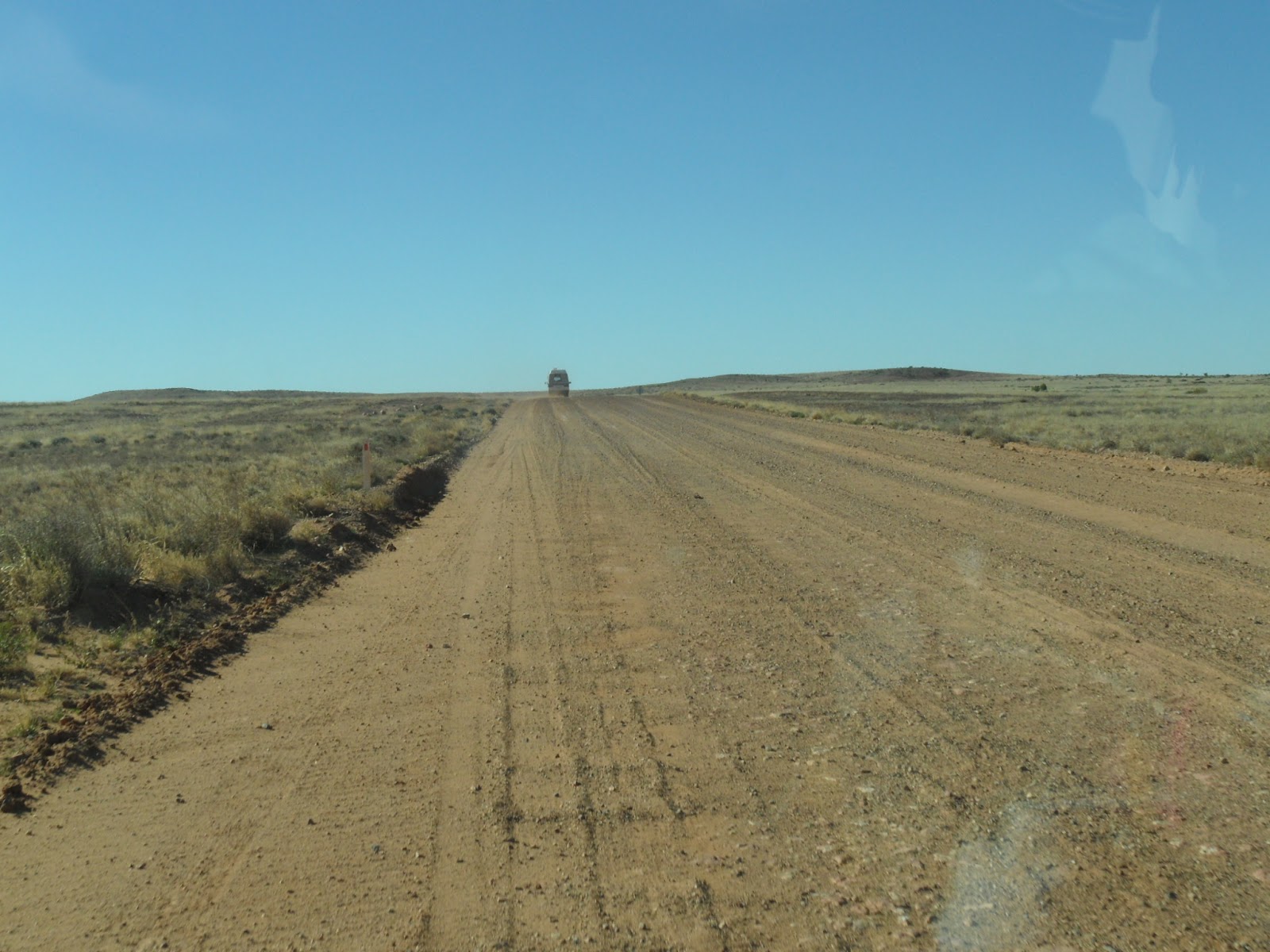
The road from Noccundra to Thargomindah is called the "Adventure Way". Good surface in the middle but variable in width. When you meet someone coming the other way, or you want to pass, you must drive over onto the gravel at the side. This is where the "adventure" comes in.

This is what happens when you don't judge that move to perfection. No-one was hurt. Just bruised pride.


Thargomindah gave us some treats. A young Kookaburra


Soon joined by its mate.

At a camping place after Thargomindah we were treated to some great views of this pair of  Red Capped Robins


On a final note, we all know that outback Queenslanders are, on the whole, fine connoisseurs of wine. When we went into the Thargomindah pub looking for a bottle of red they helpfully suggested that, while they had no bottles, they did have some casks. When they brought this one out we couldn't resist.


It was drinkable but certainly wasn't shiraz,  and I  suspect "South Australia" was a calculated insult to the winemakers of that state.

We slipped up to Proston (near Kingaroy) to visit Ruby Crane, a friend from last year's safari, and then came due south back home.

A memorable trip that will give us happy memories for years to come.

See you all next year.

Monday, July 16, 2012

Innamincka

We had achieved our second goal. We had driven the Strzelecki Track. An unforgetable experience. The smooth stretches, the corrugations, the potholes, the dust. The extraordinary views of the Strzelecki Desert. The red soil and the bright green leaves of the bushes. The utter beauty of the wilderness. The Flinders Ranges disappearing behind us. Kilometre after kilometre of pounding and slipping in the gravel ruts, without seeing anyone else for hours but our two little motorhomes. All a little scary.

We woke on the first morning at Innamincka a little later than usual and we decided to move to a campsite close to Coopers Creek. A lot of campers had moved-on that morning and we found a great spot after a little bit of exploring. At that point I somewhat blotted my copybook. As we started back to get the motorhomes I stopped for a chat with some campers. I asked important questions about which path they had used to reach their spot, had they caught any fish etc etc and when I looked up Mare, Jan and Pete had disappeared. Now, had they taken the shortest route back or had they explored the paths and tracks that we would need to use ? Well, as you can guess, I chose the wrong option. I started out along the paths and track so that I would know how to drive to the new location. Two kilometres later I arrived at the old campsite to find Mare sitting on a log (she had left her keys in Maggie) with smoke coming out of her ears. No sign of Pete and Jan. They had worked out how to get to the new place and had set off.

When we finally got settled. The new spot was first class. Right on Coopers Creek with a great view of the water and the wild life.

Not all the waterways are still flowing but the quality of the bush here is outstanding.

Firstly, I should have a word or two about the name of the river that we now sit beside. I know that I have made a number of mistakes with the spelling of place names and such (as well as sundry typos) but I am on a mission now and this part I know is RIGHT. Sturt named the green river that occasionally flowed across the channel country down to Lake Eyre as "Coopers Creek". He called it a creek because he believed that rivers flow constantly and creeks are seasonal. He seems to have been alone in this because many Channel Country "rivers" named by others are certainly seasonal. Now enter the Place Names Comittee - a group of bureaucrats who have probably only ever seen water in Lake Burley Griffin. They said that rivers in Australia named after people should not be given possessive names. The Murray River is not Murray's River, or even Murrays River, and so on and so forth. So, Coopers Creek must be known as Cooper Creek. Uniformity in naming is an essential part of the taming of the wilderness. So there. All the maps (clearly produced by a bunch of whimps) now call it Cooper Creek, but all the local signs, I'm pleased to report, still call it Coopers Creek. Anyway, I've always called it Coopers Creek and will continue to do so.

On another topic entirely, I want to draw your attention to a bird called a Grey Shrike Thrush. They have a beautiful call and look stunning. Anyone who does not know why Grey Shrike Thrushes are personally important to me will have to ask me when we get back because I don't want to risk boring those in the know by repeating the story yet again. The southern races of this bird are rather shy but I'm pleased to say that the northern ones are much more cheeky. This one landed on Maggie's mirror and proceded to entertain us.

It soon realised that it had me enthralled. It tried to encourage me to take a photo of its mate which could only be seen on the other side of the mirror.


I had been concerned for the past day or so that our house battery charge was getting low. We could still start the engine but lights, fridge and the all-important CPAP machine which enables me to breathe properly at night, were draining more power each day than we were putting in. This should not happen. When we drive,  the alternator charges all the batteries and when the sun is out,  the solar cells contribute. In the summer the solar cells can produce enough power for all our needs but in the winter they do not. We are reliant on running the engine for a few hours to fill them up. After that we can last about 3 days, more with solar help. Clearly driving up the Track had not charged our batteries. On our first night at Innamincka the CPAP machine stopped a few times. On our second it failed altogether and I spent a sleepless night. The next day I felt rotten. Our plan to spend three or four relaxing days beside Coopers Creek was not on. We had to get to 240V power as soon as possible to get some charge into the batteries and we had to get the charge controller fixed. We enquired about power at the pub but they were unable to help and so we had to get away from Innamincka.

We had planned to travel south to Tibooburra and then on to Broken Hill. Unfortunately the roads were reliably reported to be very poor after the floods and as we were going to be dependent on Mare to carry a much bigger driving load until I got some sleep, we decided to travel east through southern Queensland on asphalt roads. This decision changed (we think for the better) the scope and features of the rest of the trip.

Friday, July 13, 2012

Strzlecki Track #3 Innaminka

I found a map which illustrates where we went. I should have posted it in Strzlecki # 1 but forgot. This view shows the two tracks to give an idea of their relative size. It shows Maree (the start of the Birdsville) and Lake Eyre immediately to the north. A bit to the south is Lyndhurst which is the start of the Strzlecki.


The next map is an enlargement of the Strzlecki Track. You can see the tent symbol on the Montecollino Bore about half way along. The Blanchewater ruin is there but not well marked. As you can see the Track cuts right through the Strzelecki Desert. I have been spelling it Strzlecki not Strzelecki. I assume they are correct!!


The third day of driving (leaving from Montecollina) sarted easily. Which was just as well because we wanted to get to Innaminka that night.


A storm threatened, but passed us by.


If you check back on the second map you will see a sharp right-hand bend just near the Moomba Gas Field. The road deteriorated seriously after that bend. The cynics amongst us might say that the road to Moomba is well maintained for the trucks supplying the field. They would say the tourists get second shift. Unfortunately we were so busy with the conditions we did not manage a photo.

Innaminka is a very small town set on a hill with Coopers Creek flowing around it. The pub, the general store and the mechanic's shed (ie the town) hides behind some trees but as you can see there is one more building on the hill which rewards us with a magnificent view at sunset.
This building is the stuff of philosophical musings.  We are all familiar with major religious institutions building highly visible buildings on the top of hills and rises in suburban surroundings. These institutions take on the task of resolving mankind's historically great conflicts. They do this by rational discourse where that helps, and appeals to emotion when it doesn't.They established professional orders to assit them and developed management structures to keep the whole show on the road. But, you ask, what has this to do with a building sitting on top of a hill at Innaminka? Well, one of the greatest personal tensions of the modern world is the conflict between wanting to use up resources as fast as possible so we can live a comfortable life yet, at the same time, keeping the world as it was at some defined time in the past. For most people that time is about the time of their childhood.

What have we done to reconcile these forces? We have set up an institution! This institution has different names in different places so we shall simply call it "The Department of the Environment". Yes! That magnificent building so fetchingly catching the rays of the setting sun is the local office of the Department of the Environment. It has a foyer with displays of the excellent work carried out by this public institution, using facts where they are available and emotion when they are not, and many offices staffed by people who hardly ever get out into the real world. It all sounds depressingly familiar. Yet it does catch the rays of the setting sun.

We set up camp only a few metres away from the spot we used last year and felt quite at home.

Wednesday, July 11, 2012

Strzlecki Track #2 Oops!

I have to admit that the wish to travel up one of these exotic tracks has a lot to do with bragging rites. One can just let it out of the side of the mouth with a casual air "went up the Birdsville last year" and "did the Strzlecki this year". To be able to add "got bogged" greatly increases the impact. To have been brave (or foolhardy) enough to travel in dangerous conditions clearly cuts one above the rest. Well, not quite, as we will see.

The second day of travelling started much as the first. Corrugations and dust.
Jan Bates kindly let me show some of her photos. I will mark her's with an *

That is Maggie up in front.

We were aiming for the second (and last) suitable spot for camping on the track. The Montecollina Bore is only about 60 Kms further on. When we arrived it was quite a surprise. Fine white sand making sand-dunes with coastal bushes and grass. You would swear that the sea was just on the other side of the dunes.


There was water alright. The bore formed a small but quite beautiful pond *.


We settled in quickly and had a cup of tea. That is Maggie in front and the Bates' Toyota Coaster behind*.

After tea Peter Bates decided to move to another spot about 20 metres away and we decided to turn Maggie around. Peter B, an old hand at sandy parking spots, accomplished his task without trouble,................but Peter R..........

OOPS!!!!! Down to the hubcaps in fine sand*.

Pete kindly brought his Coaster over and we attached our snatch strap*.

And he pulled us out.


What a mess!

Once we settled into a safer spot we decided to have a campfire. The lady in the middle of the picture is Paula, the chap behind her is Hans, her husband. There were driving and almost identical Mazda as Maggie. You can pick the difference because their's has a blue stripe on the roof. Peter Bates is sitting down and Mare is bringing her chair in*.

Paula cooked a damper in our camp oven *.

Which was a great success*.


Hans and Paula were born in Germany and settled in Australia in the early 80's. I promised to let you all know that they are selling their Mazda in case you want to buy one (grin). They are selling because it is time to get their boat ready to sail from Mooloolabar to Cairns for the winter. It is a 32ft Catalina with winged keel. Cor........some people.

Friday, July 6, 2012

Strzlecki Track #1

The main aim of this trip was to fly over Lake Eyre. However, last year we drove up the Birdsville Track and in the back of my mind I  hoped that after the flight we may be able to drive up the Strzlecki Track this year. The Strzlecki Track (like the Birdsville Track) is a dirt road along the path of an old stock route. The Strzlecki has some bores still running but only remnants of civilization along its length, unlike the Birdsville, which is cut in two by the Mungerannie Hotel with fuel and water available. So 473Kms of dirt road, carry everything you need, no reception of Telstra 3G. Probably the most challenging drive that should be undertaken by a Maggie-type vehicle driven by people of our age.


Most of the early part of the track was pretty good.

The main problems lay in the washways and dips that you can't see into as you approach.

When you look south you can see the northern part of the Flinders Ranges. They seem a very long way away. The rainfall in this part of the country is very low and when you couple that with very poor soil the view is fairly bleak.

Driving was quite a challenge. The road varied from moderately smooth (for a dirt road) to a very rough, corrugated surface and back again repeatedly. The corrugations were about 10cms deep  and just far enough apart for the tyre to sink to the bottom before hitting the next one. When these patches were on a flat piece of terrain we could keep up enough speed to ride over the tops of the corrugations but when they occurred on a corner or in a dip, keeping up speed was very dangerous. Having slowed down, taking a bashing, we then had to speed up again to get on to of the bumps. After about 150 Kms we were all very tired and we stopped for the first night at the ruins of Blanchewater Station. Thought to be involved in brumby rustling in the 19C this station was, in its heyday, a very successful venture. A major flood in the 1960's destroyed the buildings which have never been rebuilt. We arrived at sunset and the sandstones looked stunning.

Bleak, unproductive land today.

The eastern sky at sunset is often beautiful.

We were all a bit tired the next morning so we decided to stay at the ruins for another day. I pretended I was a naturalist and went looking for flowers and birds. These are not flowers but brightly coloured leaves, but they made a good picture.

These are flowers, of course, but I can't find the book to identify them. I always was a very keen botanist.

This chap, a brown goshawk, did not like the look of me. I tried to get closer, leaving a clear path for him to fly away so that I could get a shot of him in the air. He fooled me and took the hard way out the back.


It was my turn to cook dinner and I rather surprised myself (as well as the others) with a casserole which I might call "beef cooked with red wine and mango ginger". Recipes are available for a small donation to the "save the goshawk" foundation.

Monday, July 2, 2012

Farina

In the 1880's when this region was first settled the state authorities decided that a town should be built to support the development of the pastoral leases. Surveys had been made and it was decided that this area would be suitable for wheat. The town was named Farina (from the latin word for flour). I kid you not.

Presumably this is why they now employ agricultural economists instead of latin scholars in the department of agriculture.

The town lasted over 100 years through flood and drought until the government stopped paying for it. Three generations lived there. It is all so sad.

The ruins attract a variety of birds.

Not all of the feathered variety.


The actual town site is still owned by the crown but the surrounding countrside is part of a large, private station utilizing dry-land farming techniques. The owner has set aside about 20 hectares of land near the creek within walking distance of the town ruins for freedom camping ($10 a night). It was so pleasant we stayed a few nights.


The Harveys had to move on and our friends from Tollington Avenue, Pete and Jan Bates joined us. So we stayed a few more nights. Jan surprised us by cooking a "Christmas in June at Farina" dinner.
We started outside


And then it started to rain so we went inside Maggie

It was quite a treat.

We are looking fairly well, I think. Here we are joined by Peter Bates
Soon we had to move down to Copley where there is a small caravan park to charge our batteries, fill our tanks, make phone calls and generally get ready for the next main hurdle in the trip - the Strezlecki Track. But before we go, just one more Quondong Pie at the Copley Bakery